I use interactive notebooks (I refer to it as The History Notebook to my students) as a Writer’s Notebook for teaching history(ok honestly, for every subject, but in this case, lets specify for just history class). Looking through Pinterest, I realize I realize that when people say “interactive notebooks” they mean the cute cut-out colorful activities with pop-ups, coloring activities, colorful paper in different shapes, and inordinate amounts of glue… and while I myself am a sucker for arts and crafts… this is not what I mean. I may have taken liberties with the definition of “interactive notebook” to mean a notebook that both students and I, the teacher, are working with and using as a tool to work through our class. I guess thats the “interactive part?
Am I allowed to do that? Anyway, I did. In this post, I will show you what the pages of an interactive notebook for analyzing any map as a primary source look like.
Benefits of using interactive notebooks to teach history with maps
Mostly, I have turned to using interactive notebooks as the heart of all my classes because I like order but, in all honesty, I have the object permanence of a squirrel. And the notebook has all the pages altogether so you don’t have to keep track of where everything is.
Also, I really believe it should be seen first and foremost as a vehicle for the writing process (and thinking process).
The interactive notebook (or in this case, the History Notebook) transcends grade level… In fact, I start out my Notebook set up, instructions, and expectations the exact same way whether the students are in in 7th grade or 12th grade. (Ok… yes, maybe a LITTLE different…:) if you have taught at both levels you are also laughing) but the overall idea and structure remains the same. Ultimately, the only real element that varies among grade levels and classes is the content.
I like to break down the thought process of analysis because I think it is important to model it for students who have never seen it before. With this in mind, I LOVE “interactive notebooks” which is mostly to say I love having a space to record the learning process for myself and for the students. [As a side note, in my personal life, I LOVE bullet journals. I love journals and notebooks of all kinds, really. Turns out…. So do lots of the students:-) ]
Anyway, back to the point….We cannot possibly remember every thought we have or observation that we make about the world.. Or at least, I certainly can’t. Kind of how I can barely remember the topic I am supposed to be talking about on this post…
We need to write things down: we need to be able to go back, reflect, edit/revise, cut/paste, delete as needed throughout the analysis process – so we see what patterns emerge, in our own lives, in our creative processes, and in our analysis. This is true not just of our own lives, but of our thinking processes as well- This works for me because its from my heart, and it makes sense with the way I think.
The interactive notebook is an effective tool for teaching history with maps because it helps students in keeping their work organized and is an easy-to-access resource for their reference throughout the year. Whether you do the print or digital version, the interactive notebook/history notebook/journal/workbook/ [whatever you want to call this] allows you and your students to slow down the analysis process so that students show their thinking, and so that you can focus on the process of analysis, not the end product. Because when we we are teaching historical thinking, it really is the process that matters so much more than the final product, which, let’s be honest, at this point, they can just google or chatgpt, or whatever. And I’m not really interested in how well they can “cheat the system” or outsmart me, or cut corners. I get it, I’m old, and I don’t know computers as well as they do. Yawn. Unfortunately, I actually love this stuff, and want to see how their brains make sense of it too. There are so many different ways to explore maps, this is just one of the ways to start getting their thinking onto paper, and to get everyone to slow down so that when the actual analysis part is done well, the writing of their analysis is no longer a daunting task, it just becomes a matter of putting the pieces together. And then, when THAT time comes, the students who have paid attention and have actually gone through the thinking processes will not have any problems, while the ones who have been doing the bare minimum will simultaneously begin whinging about how nothing makes sense all of a sudden and it will become clear to you who needs alternative approaches to learning and who has mastered the basic concepts and is ready for enrichment. 🙂
OPCVL Method for Analyzing Maps
When we start analyzing maps as primary sources, I explain to students that a major part of being an historian is working with sources. In order to use sources effectively in research, an historian must be able to perform a proper source analysis- its how you can really get to the truth of things instead of just taking someone elses word for it. In the IB program, source analysis for the history curriculum is done in a format called OPCVL(Origin, Purpose, Content, Value, Limitations). But it’s a great way to push your students’ critical thinking to the next level even if your school hasn’t subscribed to the IB program(which, at the end of the day, is just another curriculum model with a logo, let’s be real). By following this format, students can conduct a thorough analysis of historical sources, considering various aspects that influence the source’s reliability and value for historical research. It really encourages critical thinking and helps students develop a nuanced understanding of historical events and interpretations in a way that is structured and accessible.
OPCVL stands for Origin, Purpose, Content, Value, and Limitations.
Each of these categories addresses different key aspects of the source. Here is an example from a History of the Americas class. Here is what teaching history with maps through primary source analysis with the OPCVL method with interactive notebooks could look like:
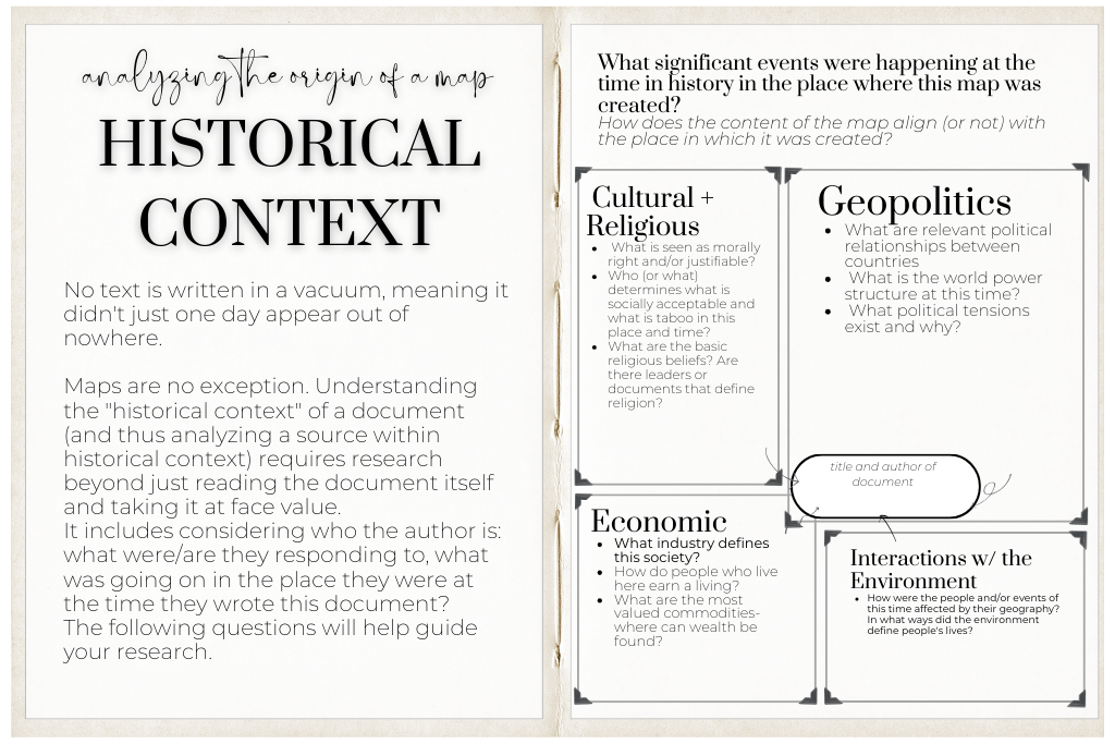
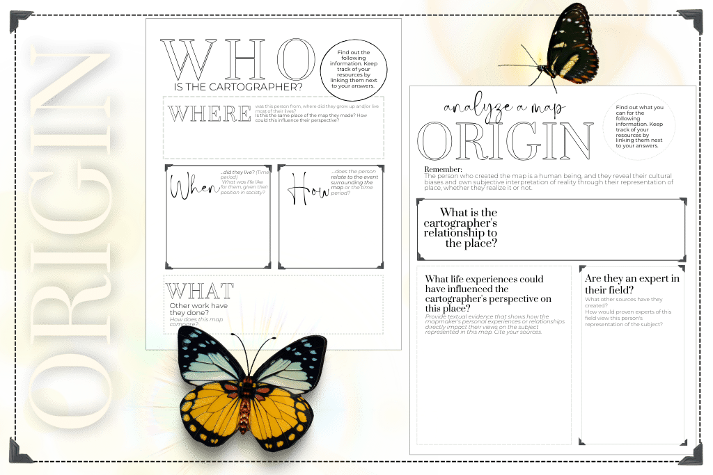
Analyzing a Map- Origin
This refers to the background information about the map. It includes details such as the author, date, place of publication, and any relevant historical context. Understanding the source’s origin helps evaluate its reliability and potential biases.
No text is written in a vacuum, meaning it didn’t just one day appear out of nowhere. Maps are no exception. Understanding the “historical context” of a document (and thus analyzing a source within historical context) requires research beyond just reading the document itself and taking it at face value. It includes considering who the author is: what were/are they responding to, what was going on in the place they were at the time they wrote this document? The following questions will help guide your research.
Questions for students when they are analyzing the origin of a map could include:
- Who is the cartographer, and what do we know about them? (or what can we find out about them?
- When and where was this map created?
-
What significant events were happening at the time in history in the place where this map was created?
-
How does the content of the map align (or not) with the place in which it was created?
-
Cartographer- The person who created the map is a human being, and they reveal their cultural biases and own subjective interpretation of reality through their representation of place, whether they realize it or not.
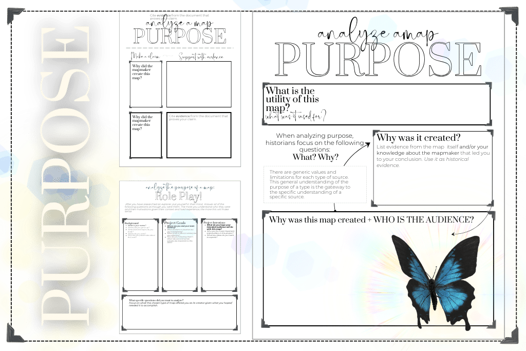
Analyzing a Map- Purpose
This element examines why the map was created. It involves considering the intentions, objectives, or motivations behind the source. Determining the purpose helps evaluate the author’s perspective and any potential biases or agendas.
When analyzing the purpose of a map, historians focus on the following questions:
What? Why?
- Why was this map created?
- What was this map used for?
- Who is the intended audience?mapmaker
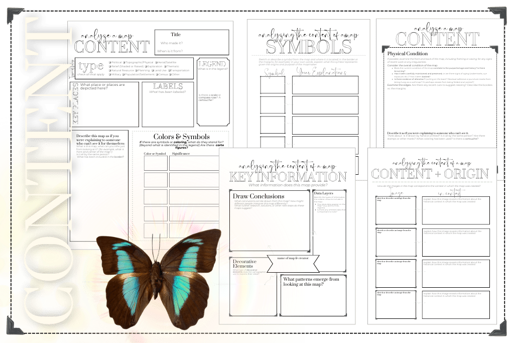
Analyzing a Map- Content
This component involves analyzing the actual content of the map. It includes examining the main ideas, arguments, or events presented in the source.
Exploring how the images on the map aligns with prevailing cultural norms, societal attitudes, or historical events provides a broader understanding of the period in which it was created.
Examples of Questions for analyzing the content of a map could include:
- What key information does this map contain?
- What symbols are used on this map, and what information do they highlight?
What geographic areas does the map cover?
Identify the regions or territories depicted on the map.
Data Layers: Identify the layers of information the creator chose to include in the map:
- How does data appear on the map? (e.g. points, lines, regions)
- Is there any omitted data that is important to note?
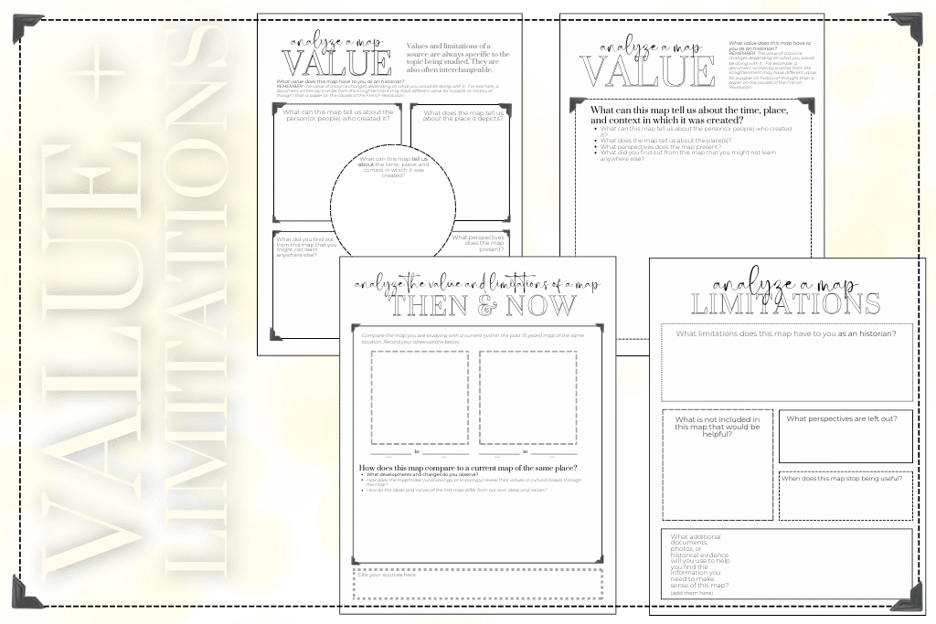
The value component focuses on assessing the usefulness and reliability of the source. Evaluate the extent to which the source provides valuable information or insights for the study of history. Consider the source’s accuracy, objectivity, relevance, and potential biases.
Assess how the map contributes to the understanding of the historical event or topic you are studying.
Questions for students when they are analyzing the value of a map could include:
- What value does this document have to you as an historian? (The value of a source changes depending on what you would be doing with it. )
- What does the map tell us about the author?
- What does the source tell us about the subject?
- What perspectives does the map present to us?
Assess the level of precision in the map’s measurements and scale.
How accurate and detailed is the map’s representation of the geography?
Analyzing a Map- Limitations
This element addresses the weaknesses or limitations of the source. Consider any factors that may affect the source’s reliability or accuracy.
These limitations can include biases, gaps in information, lack of firsthand experience, or potential distortions. Reflect on how the limitations impact the source’s overall credibility and usefulness.
Questions for students when they are analyzing the limitations of a map could include:
- What limitations does this document have to you as an historian?
- When does this document stop being useful?
- What isn’t included that would be helpful?
Compare the map’s depiction to other contemporary or modern maps for accuracy, Like in this National Geographic activity.
Research any omissions or inclusions of specific areas and their significance.
Analyzing a Map- Value
History with Maps: Interactive Notebook
Teach students how to do primary source analysis with maps with interactive notebooks. Teaching history with maps helps us comprehend the geopolitical shifts that have shaped the world as we know it. Additionally, by studying history with maps, students develop spatial awareness and critical thinking skills as they analyze the geopolitical complexities of the past; history with maps allows us to study the impact of colonization and decolonization, charting the changing boundaries and power dynamics.This carefully designed interactive student notebook organizes and records student’s historical analysis of maps while building their confidence in academic literacy by providing content specific vocabulary.
Details of History with Maps Interactive Notebook
This social studies interactive notebook, created for high school history or social studies classes, engages and supports students at each step of the analysis process: observing, inferring, questioning, and researching. This carefully designed gem brings historical concepts to life, making learning immersive and engaging. Equip yourself with this powerful resource and transform your classroom into a hub of historical discovery. Get ready to explore, analyze, and conquer history like never before!
Each page of this interactive student notebook is designed to introduce students to primary source document analysis while building higher level academic literacy. The pages can be used as inserts for students notebooks, individual activities for the separate steps of primary source document analysis, or assigned digitally through Canvas or Google Classroom.